
Tracklia: GPX, KML, GIS Maps
Updated Aug 24, 2026 · v4.5.0




View, edit, create and record GPX/KML/KMZ tracks with online or offline maps.
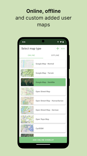
Turn GPX, KML and KMZ files into practical maps for hiking, field work, surveying and trip planning. Tracklia combines a GIS map viewer, GPS recorder and map-data editor in one Android app. VIEW AND ORGANIZE MAP DATA • Import GPX, KML, KMZ, GeoJSON, LOC and TRCK files • Keep multiple files together in My Maps • View tracks, routes, waypoints, areas, circles and polygon holes • Add photos, custom waypoint icons and georeferenced image overlays • Duplicate maps and create full backups CREATE, EDIT AND MEASURE • Draw tracks, areas and circles directly on the map • Add, move, insert or delete points • Merge, split and reverse tracks • Reduce unnecessary points while preserving the route shape • Find and remove duplicate map objects • Measure distance, length, perimeter and area • Review elevation charts, ascent and descent RECORD AND NAVIGATE • Record GPS tracks, including with the screen locked when permissions allow • Follow your position and rotate the map using GPS bearing • Check coordinates, accuracy, altitude and speed • Search addresses, coordinates and saved map objects • Use DD, DMS, DDM and UTM coordinate formats ONLINE AND OFFLINE MAPS • Choose Google Maps, OpenStreetMap, OpenTopoMap, hiking and satellite layers • Download offline OpenStreetMap vector maps • Add custom online tile overlays from a URL EXPORT AND SHARE • Export GPX, KML and KMZ files • Create configurable CSV exports • Build PDF map reports with details, photos and elevation charts • Share files, map objects and coordinates with other apps Whether you are hiking, cycling, planning an off-road trip, surveying land, collecting field data or managing GIS files, Tracklia keeps your map data organized and ready to use. Some advanced tools require Tracklia PRO.
6 years on Google Play
This app isn't currently appearing in any tracked top charts.