
Well Finder - GeoActivity
Updated Jul 24, 2026 · v1.1.340




Oil & Gas Wellsite Locator
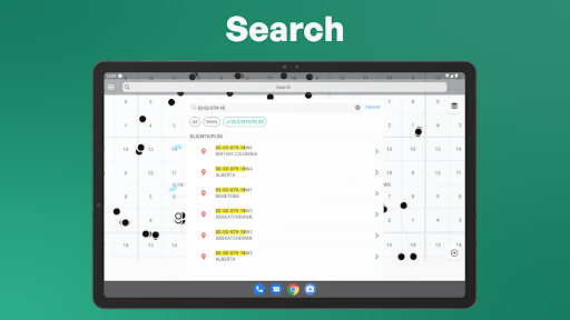
Find oil and gas wells, wellsites, land leases, and legal land locations across 17 U.S. states and four Canadian provinces with GeoActivity Well Finder. Built for oilfield operators, engineers, consultants, land professionals, service crews, and anyone who needs to locate a wellsite quickly, Well Finder combines broad well coverage, flexible search, detailed well information, and field-ready maps in one easy-to-use app. FIND WELLS AND LAND LOCATIONS Search using the information you already have: • Well name • UWI or API number • DLS and LSD • NTS • Latitude and longitude VIEW DETAILED WELL INFORMATION Select a well from the search results or directly from the map to view available information such as: • Operator • Well status • Surface location • Depth • Spud or drill date • License or permit number • UWI or API number • Additional regional well details Available information varies by state, province, and data source. NAVIGATE TO WELLSITES AND LEASES Get directions from your current location to a selected well, lease, legal land location, or dropped pin. Use the app’s navigation options or open the destination in a supported navigation app on your device. MAPS BUILT FOR OILFIELD WORK • Display wells, licenses and permits, or land-grid layers • Switch between satellite, topographic, street, and other available map views • Drop pins at custom field locations • Explore nearby wells directly from the map • Use search history to reopen recent locations quickly SAVE, ORGANIZE, AND SHARE Save frequently visited wells, leases, and custom locations for faster access later. Organize saved locations into groups by operator, county, project, customer, route, or any category that fits your work. Share individual locations or saved groups with coworkers and field crews. CANADA COVERAGE • Alberta • British Columbia • Saskatchewan • Manitoba UNITED STATES COVERAGE • Texas • Louisiana • Mississippi • North Dakota • New Mexico • Colorado • Oklahoma • California • Montana • Wyoming • Pennsylvania • Alaska • Utah • Kansas • Ohio • Illinois • West Virginia Coverage continues to expand across active oil and gas regions in North America. WHY OILFIELD PROFESSIONALS USE WELL FINDER • Find wells and legal land locations in seconds • Search multiple states and provinces from one app • Access available well details before heading to the site • Reduce time spent interpreting coordinates and land descriptions • Save and share field locations with your team • Use one consistent search and mapping workflow across regions GeoActivity Well Finder helps oilfield professionals spend less time searching for locations and more time getting the job done. Well Finder is free to download. A subscription is required for full access to well data, maps, and navigation features. An internet connection is required to search and load current well and map data. Coverage, available fields, and update frequency vary by jurisdiction and data source. Enjoy & Share! Privacy Policy: https://www.geoactivity.com/privacy-policy.htm
3 years on Google Play
This app isn't currently appearing in any tracked top charts.