
선거지도
Updated Apr 26, 2026 · v2.10
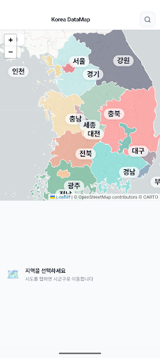


A data map that allows you to explore population statistics and historical election results at a glance using a map of South Korea's administrative districts.
The Election Map app is a data exploration web app that allows you to explore the administrative districts of South Korea via an interactive map and visually analyze population statistics and historical election results. 🗺 Map-based Drill-down Exploration You can delve deep into the map in three stages: from Provinces (17) → Cities, Counties, and Districts → Eups, Villages, and Dongs. Clicking on a Province displays the boundaries of that City, County, and District, while clicking on a City, County, or District allows for detailed exploration down to the Eup, Village, and Dong levels. Administrative district names are displayed as overlays on the map, and you can easily return to the previous step using the back button at the top. The Leaflet-based map allows for free zooming and panning and supports two map styles: Dark and Light. 👥 Population Statistics Panel Selecting a region displays the current population status based on official data from the Ministry of the Interior and Safety. View total population, gender ratio, and number of households at a glance in card format Visualize population distribution by age group using gender-separated bar charts (from ages 0–9 to 80+) Distribution of household structure (proportion of households ranging from single-person households to those with 5 or more people) Provides indicators for youth ratio (ages 15–39) and aging rate (ages 65+) Specifies data sources (Public Data Portal, Statistics Korea SGIS) and reference dates 🗳 Election Results Panel View past presidential, parliamentary, and local election results within the same regional unit. Status of Candidate Registration for the 9th National Simultaneous Local Elections 6th–8th Local Elections: Heads of Metropolitan and Local Governments, Heads of Basic Local Governments, Metropolitan Council Members, Basic Council Members (Constituency/Proportional Representation) 19th–22nd National Assembly Elections: Constituency and Proportional Representation Results Presidential Elections: Historical Vote Shares by Candidate You can view candidate names, affiliated parties, vote counts, and vote shares in a table format, highlighting the gap between the first and second-place candidates. Election statistics, such as voter turnout, registered voters, and valid votes, are also provided. 🔍 Region Search Entering a region name enables integrated search by city/province, city/county/district, town/village/neighborhood, and candidate names. Selecting a result from the autocomplete dropdown immediately navigates to the corresponding region, and you can quickly re-access recently visited regions. 🔗 URL Sharing and Deep Linking The current region, election, and tab status being browsed are automatically reflected in the URL. When you share the URL, the recipient can immediately view the same screen, and the browser's back/forward functions work naturally.
This app isn't currently appearing in any tracked top charts.