
MapCheck Pro
Updated Aug 10, 2026 · v1.0.6

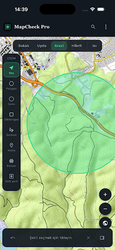


Map showing crowd density, capacity, and evacuation analysis. Export as PDF/KML.
MapCheck Pro is a map application that performs crowd density and capacity planning for event venues, public spaces, and temporary installations. Draw areas on the map, enter population data, and instantly see density and risk levels. Speed up decision-making with planning tools such as safe/maximum capacity, evacuation (T_clear), barrier, and corridor analysis. HIGHLIGHTED FEATURES • Polygon, rectangle, circle, freehand drawing and distance measurement on the map • Density, per capita area, safe and maximum capacity calculations • Risk level and heat map view • Evacuation/exit parameters and regulatory report with assumptions • Barrier, congestion point, EMS corridor and zone policies (VIP, GA, queue, stage) • Air derate, occupancy standards and what-if scenarios • Local project registration — works on your device without creating an account • Export: GeoJSON, project JSON, text report, PDF, KML/KMZ, occupancy certificate and accessibility statement • OpenStreetMap / satellite / hybrid layers and location search worldwide WHO IS IT FOR? • Event and festival planners • Security / crowd management teams • Municipal and public space operations • Consultants and GIS users PRIVACY MapCheck Pro does not require an account. Projects and preferences are stored on your device. Internet is used for map tiles and location search. Details: privacy policy. Note: This tool is for planning and decision support purposes only; it does not replace official permits. Comply with local regulations and decisions of the relevant authorities. MapCheck Pro — crowd density and capacity analysis, on the map.
0 years on Google Play
This app isn't currently appearing in any tracked top charts.