
SDVFR Next
Updated Aug 24, 2026 · v1.194

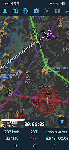


Application for planning and tracking VFR flights in Europe
This application is designed for pilots of aircraft operating under visual flight rules (VFR). SDVFR Next is the redesign of the SDVFR application. Technical support: https://forum.skydreamsoft.fr ou info@skydreamsoft.fr Coverage: Artic, France, British Isles, Eastern Europe, Iberia, Balkans, Italia, Scandinavia, Central Europe Features: - Application in English or French - Home made Europe vector map - Day and night styles - Remove upper airspaces with a ceiling filter - Traditional SDICAO map still available - Free ICAO additional maps (14 countries) - Chargeable maps available (see shop at https://skydreamsoft.fr) - Online maps (plan, terrain, satellite, hybrid) - Use your maps in MBTiles format - Use your map layers (KML, GeoJSON, SHP) - Display several maps simultaneously - Change maps according to zoom - Manage your custom waypoints - Georeferenced VAC maps (automatic zoom mode) - GPS tracking (speed vector & time bubbles) - Be alerted in the event of loss of GPS or traffic stream (GDL90) - Estimation of wind aloft - Height estimation (accurate terrain model) - Magnetic declination - Map options (auto-center, orientation) - Direct function (including localities search) - Live track - Replay tracks - Customisable black box - Export of tracks in KML and GPX formats - 2D and 3D track display - Stopwatches - GEOID correction (required on Android) - VFR & IFR Notams - Zones from SUPAIP - RTBA (very low altitude network) activations - Double-tap airspace details - Flight profile - Navigation profile - Create your navigations in just a few clicks - Configurable flight log - Take into account climb/descent times - Drift and effective wind taken into account - Overlaps (radio navigation) - Help with choosing frequencies - Export and import of GPX, KML, PLN (Flight Simulator) and FPL (Garmin) navigations - METAR & TAF & SIGMET (raw and decoded) - Wintems (18 levels and 24-hour forecasts) - WINTEM and TEMSI weather maps from Météo-France - Weather radar - Data sheets for your aircraft - Weight and balance screen - Fuel estimates - Narrow route briefing (weather, airfields and notams on your route) - Generation of complete flight report - Documentation of France, Spain, Benelux, Germany, Italy (VAC, AIP, SUP AIP, etc.) - Native integration of major sensitivity zones (ZSM) - Load your personal documents and associate them with custom waypoints - Library of VFR & weather guides, map supplements, legends, etc. - Replace GPS with your flight simulator (FS2020/4, FSX, P3D, X-Plane, FlightGear, AeroFly) - Use SafeSky or your traffic detection unit with GDL90 - Synchronise navigations, aircraft, custom points and tracks between your devices - Customisable top bar for quick actions - Numerous other customisation options
This app isn't currently appearing in any tracked top charts.