
KÉKTÚRA (hivatalos)
Magyar Természetjáró Szövetség
Updated Jul 30, 2026 · v1.3.1


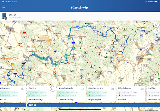

The Blue Tour (Országos Kékkör) is a complete, official travel guide with useful functions.
The official mobile application of the National Blue Tour, the Rockenbauer Pál South Transdanubian Blue Tour and the Great Plain Blue Tour with built-in tourist map, up-to-date trail, route planner, navigation, recording, news, field warnings, hike log and digital stamping option – developed by the Hungarian Hiking Association, the maintainer of the BLUE TOUR. Happy blue hiking! The main functions: • The entire tourist map of Hungary with tourist routes marked with icons, with the option to save offline (separately the base map, the relief and the marked roads layers) • The entire BLUE TOUR route is always up-to-date with the current waypoints • The rules of the BLUE TOUR, all sections and their descriptions, with data on the sections between the waypoints (also reversible) • Sights, accommodations along the route with descriptions and photos • All the signposts of the BLUE TOUR with their content • Universal route planner with guidance option for the BLUE TOUR route: you can plan between any two points in the country on the blue strip, and you can also have the waypoints automatically planned • Navigation along the chosen route even with voice commands • Route recorder • Notifications about nearby waypoints can be turned on • GPX upload (raw or in with the option to make the route navigable) • Compass, barometric altimeter, sharing your current location to request help • Officially recognized digital stamping option (also in a printed or digital certificate booklet), proof with a selfie in case of obstruction • Uploading stamps previously stamped in the printed certificate booklet to the hiking logbook • Live sharing of your position and the positions of other blue hikers on the map (with name or anonymously) • News, articles about the BLUE HIKE • Current field warnings • Basic weather data on the map • Problem reporting interface (about problems experienced on the route) • Distance and area measurement on the map • Create your own user account • Linked user accounts for children • Personal hiking logbook (separately based on stamps and route recordings, at the level of each certificate booklet and above): statistics, stamps, showing the sections already covered and the remaining ones on the map • Save your favorite places • Countless customization options
0 years on Google Play
This app isn't currently appearing in any tracked top charts.